Hawke's Bay
Visiting Napier Botanical Gardens: A Practical Guide to Napier Hill's Historic Reserve
Updated 30 October 2026
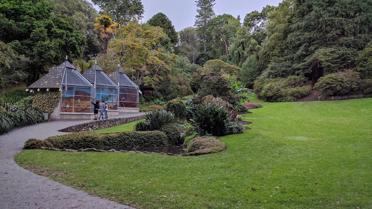
Tucked into the folds of Hospital Hill, the Napier Botanical Gardens offer one of the most distinctive green spaces in Hawke's Bay. Spanning roughly 18 acres of sheltered gullies, terraced slopes, and mature woodlands, this public park carries a personality far removed from flat municipal lawns. Rather than wide, manicured avenues, visitors encounter winding footpaths that climb through lush plantings, tiered hillside hollows, and layers of regional history reaching back to the founding years of modern Napier.
Whether you want a gentle stroll around the lower pond, hope to inspect colonial and pre-European heritage markers, or plan an energetic walk up to the ridgeline, knowing how the grounds are configured is essential. Because the reserve occupies a steep hillside setting on Napier Hill, the physical layout can surprise first-time visitors. This practical guide outlines the terrain, entry points, parking arrangements, walking tracks, and botanical features to help you plan an enjoyable visit to this historic hillside haven.
The Origins of Napier's First Public Park
To understand why the botanic gardens napier preserves look and feel like an undulating woodland sanctuary, it helps to examine how the site was first established. The reserve traces its origins directly to the mid-nineteenth century. In 1854, Alfred Domett, the Commissioner of Crown Lands, arrived at Ahuriri under instructions from the Colonial Secretary in Wellington to survey and draft a comprehensive layout for the future township of Napier. In a letter accompanying his draft survey, Domett earmarked specific public reserves for essential civic needs, including a hospital, a school, a police station, a public cemetery, and a dedicated botanical garden.
In 1855, Domett formally recommended that 18 acres be reserved for a botanical garden, alongside an adjacent 4.5-acre parcel set aside for a cemetery. When Napier was officially declared a borough in 1874, the Provincial Government had already established the botanical reserve. For decades, until the extensive reclamation of low-lying Napier South following later urban growth and landscape changes, the gardens stood as the township's sole public park.
Transforming this steep, rugged terrain into an inviting public amenity proved demanding. Early caretakers Burness and Burton faced an unforgiving landscape characterized by difficult gradients, dry summer periods, and very limited municipal budgets. Much of the arduous physical labour required to terrace the steep slopes, clear dense scrub, and lay out the original tracks was carried out by prison working parties. To combat droughts across those early decades, caretakers made use of natural wells that had been sunk in the lower gardens for military detachments stationed nearby.
In 1875, Mr Burton was appointed as the reserve's first trained gardener. His initial major task was planting stands of Pinus radiata on the exposed slopes between Enfield Road and Napier Terrace to stabilize the limestone soil and create shelter belts against coastal winds. Burton continued using prison labour to form stepped terraces and level trails. Plants and trees were sourced from other New Zealand settlements and carried into Hawke Bay by captains of sailing ships calling into Napier's busy port. Early regional settlers, notably the missionary and naturalist William Colenso, donated specimens and maintained an active interest in expanding the collection. Later, formal patterned flowerbeds were introduced, giving the hillside its distinctive combination of structured beds and wild canopy.
Access Points and Parking Arrangements
The botanical gardens napier nz maintains two primary entrances positioned at opposite elevations of Hospital Hill. Because of the steep terrain separating the two gates, selecting the right entry point is an important practical consideration for your walk.
The Lower Entrance: Spencer Road
The lower entry point is situated at 19 Spencer Road on Hospital Hill. This entrance serves as the most logical starting place for families with young children, casual walkers, and anyone seeking to avoid an immediate uphill climb. At the lower Spencer Road entrance, visitors will find a small off-street car park that includes designated disabled parking bays. Because this car park has limited capacity, spaces can fill quickly during fine weekend afternoons and public holidays.
Entering from Spencer Road places you right beside the flattest, most accessible quadrant of the reserve. From the gate, you have direct, level access to the lower lawn areas, the duck pond, and the aviary, allowing visitors to experience the core amenities of the gardens without having to negotiate steep slopes straight away.
The Upper Entrance: Napier Terrace
The alternative access sits along Napier Terrace, high on the ridge bordering the old cemetery grounds. There is no dedicated council off-street car park at this upper gate, but ample roadside parking is available along Napier Terrace. Parking along the street here allows you to begin your visit at the crest of the hill, enjoying elevated views through the treetop canopy before descending into the gullies.
The key logistical factor when starting from Napier Terrace is the return walk. While strolling downhill into the gardens is effortless, every metre descended along the tracks requires an uphill return to reach your vehicle. For visitors with limited mobility or tired legs, beginning at the Spencer Road base remains the more adaptable option.
Navigating the Hillside Walking Tracks and Terrain
The botanical reserve occupies a natural hillside amphitheatre, which shapes the nature of its paths. Rather than uniform flat walkways, the grounds feature a network of tracks climbing between the valley floor and the upper rim.
Path Surfaces and Stroller Considerations
The lower basin immediately surrounding the Spencer Road entry features sealed, gentle pathways. These sections are manageable for strollers, pushchairs, and casual walking. Visitors can comfortably circle the duck pond, observe the aviary, and rest on the shaded open turf without facing significant barriers. However, moving beyond this lower basin requires navigating the natural topography of the hill.
Paths climbing toward the middle and upper terraces include a variety of surfaces, such as paved sections, formed steps, compacted gravel, and earthen paths cut into the hill. Shaded dirt stretches can become slick during damp weather, particularly under fallen leaves in autumn or winter. Sturdy walking shoes with reliable tread are recommended if you plan to venture past the lower lawn. Using prams or wheelchairs on the upper ascending paths is generally impractical due to steps and steep gradients.
The Historic Military Track
Among the most significant pedestrian routes through the reserve is the historic Military Track. Running along the spur between the Botanical Gardens and the adjacent Old Napier Cemetery, this path dates back to the late 1850s. At that time, British troops of the 65th Regiment were garrisoned at barracks situated on the hilltop above the reserve. To transport food, water, and essential equipment up from the junction of Chaucer Road South and Spencer Road, soldiers established a direct walking track.
This Military Track was intentionally aligned to be far less steep than the surrounding road routes up the hill. Today, it remains the most practical and comfortable walking route between the lower gully and the top ridge. As it winds up the spur under tall canopy trees, the Military Track offers pleasant, elevated views across the gardens below, making it both a scenic corridor and a direct physical link to nineteenth-century military life.
Key Garden Landmarks and Historic Features
Beyond its botanical interest, the reserve preserves several physical landmarks from different eras of Napier's development, spanning nineteenth-century military occupation, pre-European Māori settlement, and twentieth-century civic upgrades.
The 1961 Aviary and Duck Pond
During the two world wars and the economic struggles of the Great Depression, little municipal funding or maintenance was directed toward the reserve. By 1960, the grounds had fallen into a neglected state, frequently utilized merely as a steep pedestrian shortcut up Hospital Hill to the old Napier Hospital complex. In 1961, Napier City Council undertook a comprehensive revitalisation programme designed to restore the grounds and rekindle civic engagement.
As part of that 1961 initiative, council staff constructed the lower duck pond and an aviary dedicated to free-flying budgerigars. Both features remain prominent focal points in the lower precinct today. The aviary and pond create a tranquil family setting, where bird song and shaded water margins provide an attractive rest stop near the Spencer Road gate.
Soapsuds Gully and the 1858 Military Well
Near the lower southeast section of the grounds lies a spot with a colourful connection to nineteenth-century garrison life. In 1858, when soldiers from the 65th Regiment occupied the hilltop barracks, a well was dug in the lower part of the botanical reserve to supply freshwater to the troops above. Wastewater from washing military uniforms was routinely poured down the hillside, leading locals to nickname the gully "Soapsuds Gully".
In 1964, the site of this original 1858 well was permanently marked with an ornamental stone parapet, which visitors can still view today. Along with the remnants of a second historic well, these structures highlight the practical water storage systems relied upon more than a century ago to sustain both soldiers and early botanical plantings through dry seasons.
The Upper Terraces and the Terracotta Fountain
Ascending to the upper gardens leads to a quieter atmosphere shaded by dense canopies. A central decorative landmark within this higher section is a heritage terracotta fountain. Restored in 1970 to recapture the formal ornamental character of early Victorian gardens, the fountain serves as a historical focal point among the upper terraces, even though it lost its topmost tier to vandalism in later years.
The upper slopes also preserve additional historical sites. Walkers can identify the former building site of the sexton's cottage, which served the adjacent burial grounds, along with recorded pre-European Māori middens. These middens provide tangible evidence that the strategic heights of Mataruahou were inhabited and utilized centuries before European surveyors drew the town boundaries.
The Old Napier Cemetery
Bordering the upper boundary of the gardens along the top of the spur sits the Old Napier Cemetery. Although maintained as a separate historical site, its story is deeply intertwined with the botanical reserve. Both spaces were planned side by side in Alfred Domett's 1855 survey, sharing the high ridge of the hill.
Walking through the cemetery via the upper Military Track gate offers a poignant window into early colonial settlement in Hawke's Bay. Inscribed headstones, family plots, and memorial monuments record the lives and early passings of pioneer families, missionaries, civic leaders, and soldiers of the 65th Regiment. The epitaphs reflect the harsh realities of nineteenth-century life, maritime disasters, and epidemics, making a short walk through the cemetery grounds a thoughtful complement to exploring the gardens.
Specimen Trees and Botanical Heritage
From an arboricultural perspective, Napier Botanical Gardens represents an enduring open-air collection of nineteenth- and twentieth-century trees. During the major council revitalisation project in the early 1960s, workers carried out an extensive clean-up and formally name-tagged specimen trees across the slopes, many of which were already approaching a hundred years of age.
Today, those tagged specimen trees have matured into grand specimens, providing dense shade and a microclimate protected from coastal winds. The combination of exotic conifers planted during Burton's tenure, deciduous broadleaves, and native undergrowth creates a verdant canopy that shelters birdlife and invites peaceful contemplation throughout the changing seasons.
Practical Visiting Tips
To help make your visit comfortable and straightforward, keep these practical points in mind:
- Choose Sensible Footwear: While lower paths around the duck pond are smooth, upper tracks involve dirt surfaces, stone steps, and exposed roots. Wear sturdy walking shoes with reliable grip, especially if rain has fallen recently.
- Match Your Route to Your Energy: For a vigorous hill climb, start at the Spencer Road entrance and ascend the Military Track up to the Napier Terrace ridge. For a relaxed outing with little elevation gain, remain in the lower basin around the aviary and pond.
- Plan Around Shaded Microclimates: The sheltered gully protects walkers from strong Hawke's Bay sea breezes, making it an appealing refuge on windy days. On warm summer afternoons, however, the enclosed gully can become humid, so bringing a water bottle is a sensible precaution.
- Time Your Arrival: The gardens are typically quiet during weekday mornings, offering ideal conditions for peaceful walks and photography. Sunny weekend afternoons draw more local visitors and families to the duck pond and lower lawns.
Connecting Your Visit to Surrounding Attractions
Because the botanical gardens are located centrally on Napier Hill, pairing a visit with other nearby parks and landmarks provides a full day of sightseeing across the city. Here are several notable spots to consider:
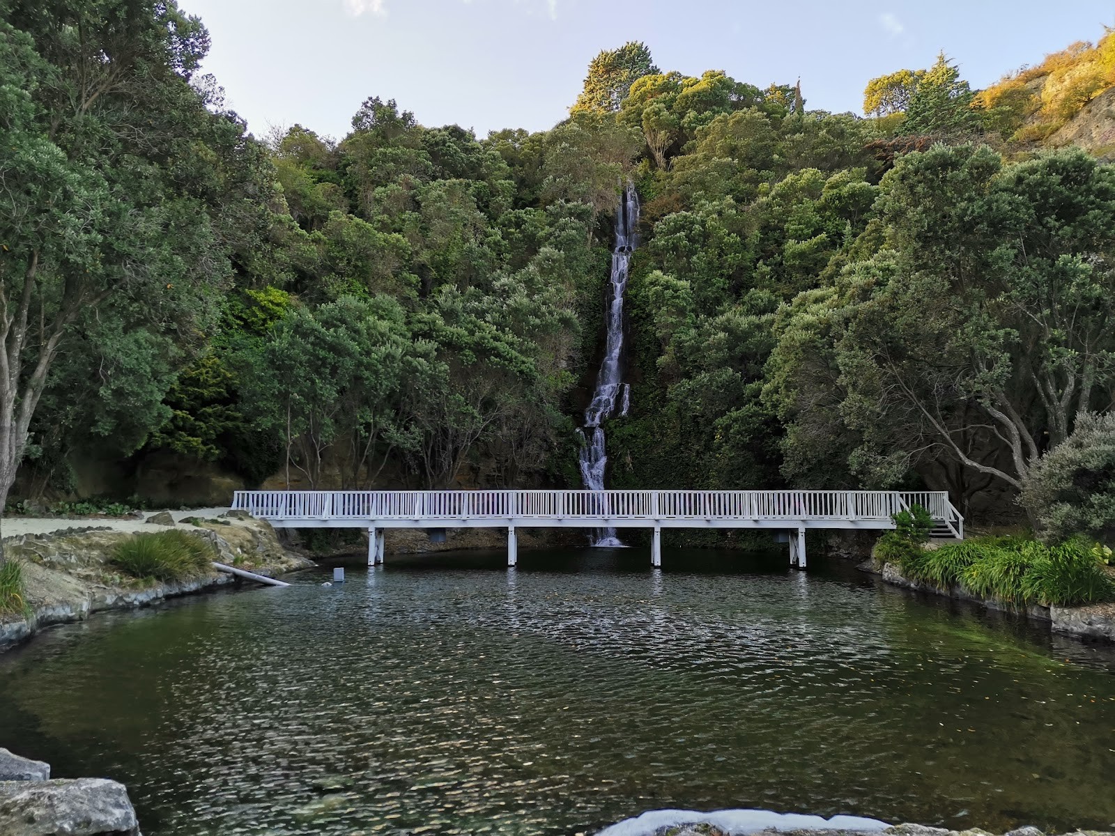
- Centennial Garden & Waterfall: Located at 54 Coote Road at the base of Bluff Hill, this reserve occupies a former quarry once worked by prison labour. Developed in 1974 for Napier's centenary, it features crushed limestone paths, rock gardens, and an artificial waterfall cascading down a 40-metre limestone cliff face, offering a striking contrast to the woodland setting of the botanical reserve.
- Bluff Hill Lookout: Situated on Lighthouse Road atop Bluff Hill Domain, this lookout delivers sweeping panoramic views across Hawke Bay and the working Port of Napier, making it an excellent vantage point to visit after walking the hillside trails.
- Kennedy Park Rose Garden: If you enjoy formal floral collections, this garden on Storkey Street in Marewa contains thousands of rose bushes covering hundreds of named varieties, reaching peak bloom from mid-November through the summer months.
- Sunken Gardens: Positioned on Marine Parade, these sheltered coastal gardens provide flat, accessible floral displays tucked beneath street level right along the sea front.
- Kahukura Hawke's Bay Museum (MTG Hawke's Bay): Located on Tennyson Street, this cultural institution houses regional archives, fine arts, and heritage exhibits that illuminate the colonial history of the gardens and Napier's broader development.
- Perfume Point: Situated on Nelson Quay in Ahuriri, this scenic point offers sea views where the inner harbour meets Hawke Bay, ideal for an open coastal walk.
- Ahuriri Estuary Walking Track: Located off Humber Street in Pandora, this flat, wide wetland trail provides opportunities for birdwatching across the restored estuary flats.
Whether stopping for a brief picnic by the aviary or taking the time to climb the Military Track to the Old Napier Cemetery, the Napier Botanical Gardens offer a memorable encounter with the living landscape, mature trees, and historical foundations of Hawke's Bay.
Cover photo: Napier Botanical Gardens - Gustavo Andres Herrera
By Alyssa.
Sources and further information
Sources checked: 2026-10-30.